
Setting off from the UK on September 2nd, 2020 we are back on the road again, crossing the Chunnel (Channel Tunel) into France.
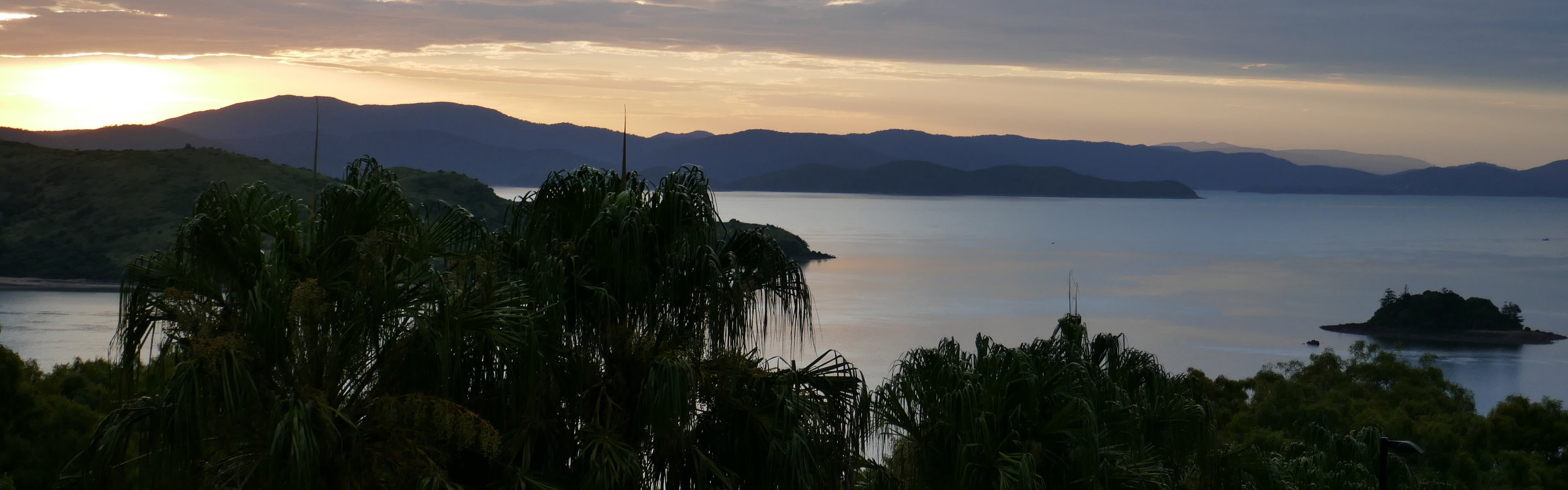
We are currently overlooking Lake Annecy from our campsite Le Panoramic, up on the hills above the lake (GPS N45.8428, E 6.14129).
Our European motorhome tour 2020 has started well. Our plan is to explore a little bit of France, mostly around the Mont Blanc area, and then cross into Italy, where we intend to stay for most of September and October. If time and COVID allow

Our 3 months road trip in Norway has been epic, from July to September 2019 we have been traveling across the length and breadth of one of the most beautiful countries on earth, experiencing some of the best of Norway. We ventured above the Arctic Circle to bask under the midnight sun at the top of Europe’s Nordkapp (North Cape). We found lonely roads and places rarely visited by tourists in the most remote rural settings and sparsely populated areas of Finnmark. Among the awe-inspiring landscapes, there has been no shortage of amazing wildlife to keep us entertained, such as reindeer, eagles, huge colonies of birds including the super cute puffins, plus numerous whales, dolphins, minks, etc


I have already written extensively about our travels in the Far North (see previous blog posts on Norway), so in this post, I will be describing some of the highlights of the Western and Southwestern Fjords, as well as some of our favorite moments in Central and Southern Norway. Most of Norway’s visitors tend to concentrate on these areas and it is not difficult to understand why, since here you can find the essence of what this country is about. These areas are more easily accessible with flights to larger airports such as Bergen or Oslo, so making it easier for exploring with a rental car or with a bus and/or train journeys.
We traveled by motorhome and found no shortage of fantastic campsites as well as the most amazing wild camping spots on this whole trip. Read on to find out more about some of what we got up to:
Geiranger Fjord
My last blog post found us witnessing a mountain rescue by the famous 11 hairpin bends of Trollstigen mountain road. There was certainly plenty of drama on this road, but little did we know that the dramatic landscapes would not end there. We followed along the 68km long road between Trollstigen and Geiranger, which is another one of the 18 tourist routes in Norway, taking us just over 2 hours to complete with few stops for photos of the mountainous landscapes. This road is beautiful with the descent into the small town of Geiranger being one of the highlights. More hairpin bends here with extraordinary views over the valley and the stunning Geiranger Fjord. This Fjord is deservedly one of the most visited tourist sites in Norway, and in 2005 was listed as a UNESCO World Heritage Site. It was very busy when we arrived with two large cruise ships moored at the town’s harbour, but we did not linger here for long and soon made our way to our fantastic campsite overlooking the fjord, where we spent a very peaceful night overlooking the still waters of Geiranger Fjord.
Evening view from our motorhome on the shores of Geirangerfjord surrounded by stunning mountain scenery, see the Geiranger town in the distance.
Geiranger Fjord is arguably the world’s greatest Fjord with its natural features consisting of towering cliffs rising up from the deep blue waters of the Fjord; simply majestic. From the water one can appreciate the many tumbling waterfalls and small farms perched on the top of the high cliffs. Looking up from our cruise boat it looked truly extraordinary that anyone would think this inhospitable terrain could be farmed. Doing a cruise along the Fjord is something that should not be missed when visiting this area. We chose to do a ferry cruise (boarding the ferry on foot, leaving our motorhome parked by the harbour) the Geiranger to Hellesylt ferry ride was stunning and we would totally recommend it, although there are other cruise options we felt the ferry ride was a great option for us. We bought the return trip ticket as we boarded the ferry at a cost of £81 for both of us. It is possible to board the ferry with a motorized vehicle, including a motorhome, but it will cost a lot more, so we opted to be foot passengers. There are other cruise type options that can be bought from the ticket office by the harbour.
Dalsnibba
Driving our motorhome up and out of the Geiranger valley on the Rv63 we climbed higher and higher towards the viewpoint of Dalsnibba, the highest point on this journey which was at 1500m above sea level. A place that offers the most incredible views of the Geiranger Valley. Totally worth paying the toll road ( £14) to get there. The drive is not for the faint-hearted with hairpin bends galore, but venture up there and the rewards will be sweeping views of snow-capped mountains and the Geirangerfjord Valley down below. Truly spectacular!
All smiles at Dalsnibba, one of the most beautiful viewpoints in Norway.
There is a viewing platform, the Geiranger Skywalk with see-through glass and a vista that goes on forever. You will not have it to yourself though, with many tourist buses making the journey up there, it is very busy. There is even a public bus that takes punters on this journey twice daily, during the summer months. Take warm clothes, since it may well be cold and windy. The journey is often better than the destination, but in this case, both will take your breath away.
Jostedalsbreen National Park
Mainland Europe’s largest Glacier is indeed a mighty natural wonder. We stayed 5 days in this area, exploring the Northern and Southern sides of the National Park. Here more than ever one can appreciate the urgency in finding solutions for the doom and gloom of climate change. Jostedalsbreen has also recently succumbed to climate change and like many other world glaciers, it is fast receding.
We started our visit with a drive along the shores of Lake Lovatnet where we learned about the tragic landslides that triggered a tsunami sweeping away entire villages. The first one occurred in 1905 when a large chunk of the mountainside plummeted into the lake causing a massive wave that destroyed the nearby villages of Bødal and Nesdal killing 63 people, only 9 bodies were ever found. The survivors rebuilt their villages on higher ground, but in 1936 a huge rock came down from the mountain causing another tsunami and destroying the villages again with the loss of life of 72 people or more.
The narrow but good road along the shores of Lovatnet Lake towards the memorial site and Kjenndalsbreen. The turquoise blue glacial waters of the lake, surrounded by mountains and waterfalls make this area an incredible place to visit.
In 1950 there was yet again another landslide, but luckily this time there were no fatalities and minimal damage. We visited the memorial to the lost lives and also spotted the steamboat “Lodalen” which was used for carrying passengers around the lake as it was swept away inland by the tsunamis. Its wreck can be seen via a path near the memorial site.
Driving on along the narrow road with the Lake to our right side we arrived at the Kjenndalsbreen, which is the least popular of the four glacier arms of the mighty Jostedalsbreen, but really worth the visit for the beauty of the drive and the easy hike to the Glacier arm…without the crowds.
Parking area by Kjenndalsbreen. From here it is an easy walk to see the glacier arm.
There is a small toll to pay and we had to do it in a very old-fashioned way by putting about 40 NOK (around 4,50 Euros) in an envelope and writing our number plate on there. The road is slow going, but there is a large parking area and also an easy to follow trail towards the glacier tongue.
Briksdalsbreen
Most visitors to this area will want to visit Briksdalsbreen, the most famous glacier arm of Jostedalsbreen, and for good reason. It is stunning, we had visited last year when our cruise ship anchored at Olden, but this time it was a totally different experience for us. We stayed overnight at the amazing Melkevoll Bretun campsite with stunning views of glaciers and waterfalls, it was the BEST campsite ever. There are also great pitches for tents and or cabins for people who are on a road trip by car/bicycle etc. Check out the picture below.
Melkevoll Bretun campsite is set in the most amazing location, can you spot our motorhome just below the cabins in the distance? Yes, it is a glacier tongue on the top of that mountain just ahead, unfortunately, it did not show well on this photo.
We were able to visit the impressive Briksdalsbreen in the evening, soon after dinner and have it all to ourselves. The hike from the campsite to the glacier tongue is about 6 to 7 km upwards, but it is not a particularly difficult hike – although not a walk in the park either.
Yes, that is me waving from the bridge, and getting soaked in the spray. The path continuous upwards along behind the waterfall.
There were only us and another couple visiting the glacier tongue in the evening. We asked them to take our picture.
The hike is super scenic, passing white water rapids, surrounded by lush green cliffs, waterfalls tumbling down from the melting glacier above and the final arrival at the impressive Briksdalsbreen with the blue lake fed by the melting glacier waters.
Loen Skylift
Another amazing highlight of this area is this fabulous cable car. One of the steepest in the world, it whisks you up to Mt. Hoven at 1011m above sea level in just 5 minutes. The views from the top are just stunning and there are various trails that can be hiked from the cablecar station. After enjoying coffee and cakes from the restaurant, we decided to do a short hike which ended up being a lot longer than we had planned. Since we enjoyed the views so much we just kept going upwards and ended up at the summit of Staurinibba at 1,379m above sea level.
Epic views from the Skylift.
At the summit, only these views could make us forget our thirst.
Completely forgetting that we had not brought any water with us, we carried on towards the summit. It was a sunny day and the hike to the summit was quite strenuous, we felt a bit silly for not coming better prepared, although we did have a snickers bar with us, so at least we were not hungry. Totally worth it for the views, but my advice is “never go hiking in the mountains without good preparation, snacks and plenty of water”.
Leaving the Loen area behind we headed towards our next destination, the Gaularfjellet scenic route, which is a road leading across Gaular, the mountain between Dragsvik and the Sognefjord, it was a serene drive with very little traffic. The drive skirts the fjord before snaking up towards the highest point of Gaularfjellet. Mountains all around and views of glaciers in the distance. We caught a ferry from Dragsvik Kai to Hella, staying on the Road 55 Sognefjord Vegen traveling towards a very special museum.
Norwegian Glacier Museum
This striking museum dedicated to the dissemination of knowledge with regards to glaciers and climate is a leading center in Norway. Designed by Professor of architecture, Sverre Fehn, the receiver of the 1997 Pritzker award (the highest international award an architect can get). The building itself is very striking, set among green fields, surrounded by mountains and glaciers. It even has a family of model mammoths outside
Norwegian Glacier Museum is an architectural success as well as a great place to learn all about glaciers.
Fantastic interactive displays, with exhibitions presented in 13 languages. We loved all the exhibitions and in particular the one about climate change, also the panoramic film about the Jostedalsbreen Glacier, being able to experience what it feels like walking through a glacier, learn why the glaciers are in motion, see how crevasses are formed, carry out experiments with 1000-year-old ice from the nearby glacier and so much more. If you find yourself in this area, don’t miss this fantastic museum.
From the museum, we drove towards the pretty town of Solvorn, where a very small ferry (Brian had to reverse our motorhome into this one) was waiting to whisk us over the other side of the Lustrafjorden to gorgeous Ørnes. Keen to visit a very special Stave Church, the Urnes stavkyrkje is a UNESCO World Heritage site perched on the hill with views over the Fjord, in an idyllic setting. Dating from the 12th Century, it is Norway’s oldest surviving place of worship. Covered in fascinating wood carvings, it was definitely worth the detour we took to visit it.
Urnes stavkyrkje (Stave Church)
We stayed overnight for free, overlooking the Lustrafjorden and enjoyed an amazing sunset sipping a glass of wine (GPS 61.30005, 7.31578). The next day we woke up to heavy clouds and rain, so it was time to move on. The rain did not stop all day as we drove past small settlements, narrow roads nestled between the fjord and the mountains. It was not a road for the faint-hearted, driving a motorhome in Norway was not always very easy, particularly when rain and fog accompanied our travels.
The 18 Norwegian Scenic Routes
There are 18 Scenic Routes (which used to be called National Tourist Routes) in Norway. These are some of the most beautiful roads in Western, Central and Northern Norway, along the coast, and across mountains. The project took close to two decades and hundreds of millions of kroner to complete. An initiative that aimed to combine nature, culture and great design. Several renowned Norwegian and foreign architects and designers were involved in creating resting areas, viewing points that could become a more memorable experience.
We drove them all, in total just driving the scenic routes we covered a total of 2,136 km, and we managed to link them in a way that made sense without having much backtracking. Each scenic route was memorable, some of our favorites included: Senja and the Lofoten Islands, The Atlantic Road, The Geiranger-Trolstigen and the longest of them all the amazing Norwegian Scenic Route Helgelandskysten ( part of Kystriksveien which runs from Steinkjer to Bodø) where we crossed the Arctic Circle at 66 degrees northern latitude.
I have already written about the above Norwegian scenic routes, so for the purpose of this blog, I will mention some of our favorites in Western, Central and Southern Norway.
- Aurlandsfjellet, in Western Norway, is a road of contrasts between the fjord and the high mountains with the viewing point at Stegastein being a big highlight. We chose to drive this scenic route instead of taking the much faster road tunnel that runs under the mountains instead. The 24.5km tunnel is the world’s longest road tunnel and it would certainly have been quite an experience to drive it, but we have driven so many fantastic road tunnels during this trip already that choosing stunning mountain scenery over the long dark confinements of a tunnel was a no brainer for us. Opening in 1967 the road runs from Lærdalsøyri to Aurlandsvangen over the mountains and the highest point is 1,306m above sea level. The road is closed in the winter and snow lies on the mountain throughout large parts of the summer, so it has been nicknamed “the snow road” for obvious reasons.
Viewing point at Stegastein
After completing the above road trip we stayed overnight at a campsite in Flåm (GPS 60.8627, 7.1069) conveniently located next to the famous Flåmsbana. We intended to ride on this railway line which is considered Norway’s most scenic train journey. The railway line is part of the Bergen Railway connecting Oslo to Bergen. Our ride would be just the 20.2 km (12.6 miles)through the Flåmsdalen valley between Flåm and Myrdal and then back to Flåm. Because of its steep gradient and scenic surroundings, the Flåm Line is now almost exclusively a tourist service and has become the third-most visited tourist attraction in Norway. The line’s elevation difference is 866 meters (2,841 ft) with a maximum gradient of 5.5 percent.
Riding the Flåmsbana railway.
The train will stop at Kjosfossen Waterfall, be ready for a lovely surprise.
The train stops briefly at the Kjosfossen Waterfall giving passengers a chance to disembark on the viewing platform for a short break. Norwegian folk music starts playing as a mysterious woman with long hair and a red dress emerges from behind the little stone cottage, dancing to the haunting tune of a Norwegian folk song. She is supposed to be the legendary “Huldra”, an elusive forest spirit from Norse mythology. Although it sounds rather “cheesy” we actually really enjoyed this little surprise.
We lucked out with the weather and enjoyed a fantastic ride, but I would not recommend it in bad weather since it is all about the views. Note that only certain windows, usually the last and front of your carriage can be opened, something quite useful for taking good photos.
- Hardanger was another favorite of the scenic routes, running through dramatic mountain scenery it is a real feast for the eyes, the road at times follows a shelf along a steep-sided valley. Rich pickings from the endless apple orchards will also be on the menu. But it is the thundering waterfalls that are the main attractions here, they are all different but equally stunning. The main ones to visit are Steinsdalsfossen (where you can walk behind it), Vøringsfossen, Skjervefossen, Låtefoss (with the twin falls) and Furebergfossen. Certainly, a quick stop and or a hike to see them from close up is a must for waterfall enthusiasts. This scenic route has three “arms” that are connected by ferry crossings, plus there are also few tunnels and bridges.
Steinsdalsfossen, you can walk behind this waterfall.
Låtefoss, these twin falls are beautiful, and really thundered with all the recent and ongoing heavy rain.
Set in such idyllic valley, Vøringsfossen is very special.
We enjoyed them all, apart from losing my mobile phone at Vøringsfossen, which was totally my fault as I tried to balance an umbrella (it was raining) whilst trying to film the waterfall with my mobile phone. The Vøringsfossen Waterfall cascades from the Hardangervidda plateau down into the valley of Måbødalen with a free fall of 145m and a total fall of 182m, it is one of the most visited tourist attractions in Norway and totally worth a visit, just hold on to your mobile phone and don’t lose it as I did, you won’t get it back!
- Sognefjellet scenic route was an important transport artery linking the coast and inland areas, and now provides a drive of powerful impressions with dramatic mountain scenery. The road makes its way up to the summit at 1,434m above sea level, making it northern Europe’s highest mountain pass. We started our journey in Lom, where we visited its beautiful Stave Church.
Knut Wold’s stone sculpture, like a giant stone window into the landscape.
At the Mefjellet stop, you will find Knut Wold’s stone sculpture which provides an interesting perspective into the mountainous landscape. There are a number of hiking options in the Jotunheimen mountains with alternatives to suit all fitness levels.
- Norwegian Scenic Route Ryfylke is 260 km long and it was for sure one of the most challenging drives that we have done in Norway. Sections of the road, particularly over the mountain to Røldal, are narrow with many hairpins bends to navigate. We drove along barren mountains, covered in colorful moss, lush hillsides displaying the most stunning Autumn colors and finally descending towards the southern point of this road where you will find Lysefjorden. There are two short ferry trips that gave us a chance to experience the fresh sea air of the fjords.
Along this route, you will find Preikestolen (Pulpit Rock) and the Kjerag boulder with Lysefjorden in the background, both very popular with hikers. Brian and I had our hearts set at hiking Preikestolen, but the filthy weather was holding us back. We stayed put for two nights at a beautiful location by the Lysefjorden (GPS 58.9102, 6.07785) waiting for a dry day. Our wait paid off and on the 3rd day, we drove to the parking area by Preikestolen (Pulpit Rock) to enjoy one of the best hikes in Norway.
Preikestolen also know as Pulpit Rock
Hiking Pulpit Rock is often described as a huge highlight of a trip to Norway and one can definitely appreciate why it is so popular. We did the hike mid-September/19 when the summer crowds had gone home. We were not alone on the trail, but it was not super busy either. The hike is classified as moderate with an about 334-meter ascent and perhaps two or three more taxing uphill sections. Quite steep at the very beginning of the hike, interestingly many of the uphill sections having stepping-stones that were laid by Nepalese Sherpas. There is also a boulder-filled section halfway up, which was a little bit more challenging, but certainly not too bad.
Pulpit Rock, can you see me waving in a pink top? No, I am not the one at the very edge.
Preikestolen is an almost vertical rock face towering over Lysefjord at a height of 604 meters, it was carved during the last ice age more than 10,000years ago. This impressive place will leave you speechless, the sheer drop is scary and exhilarating at the same time.
Brian and I at Preikestolen also know as Pulpit Rock
There are no safety barriers and people do crazy things here, watching people jump up and down at the very edge or dangle their feet from the edge to get the perfect Instagram picture was at times almost heartstoppingly scary. A fall from here will be fatal and the unlucky faller will have at a full 10 seconds to contemplate his/her fate before hitting the icy waters of the fjord directly below.. Brian and I agreed beforehand that we would both be sensible and stay away from the edge.
Altogether it took us about 4 hours to complete the hike and return to our home on wheels, after the walk of about 3.8km each way. If you find yourself in this corner of Norway and you enjoy hiking, don’t miss out on this incredible hike, probably our favorite one in Norway.
Oslo
Nestled between the Oslofjord and lush green hills, it is a very exciting city to explore.
Oslo is an ideal walking city, with many attractions easily reached on foot from the city center. We bought the 48-hour Oslo Pass at a cost of about 655 NOK,which includes travel on all public transport and entrance to most museums and attractions. For us, it was easily worth it.
Checking out the weather forecast we decided to do most of the museums on our first day of exploring since it was going to be a wet day, being indoors was a winner. We took a bus to the city center and from there made our way, via a ferry link to the Bygdøy peninsula where there are five national museums.
Our first stop was the Fram Museum (Frammuseet), in my opinion, a must-visit. This magnificently restored polar ship is housed inside the museum and it is possible to go aboard it to explore all its nooks and crannies and imagine what it would be like to take part on the famous polar expeditions lead by the legendary explorers Fridtjof Nansen and Roald Amundsen to the Arctic and Antarctic. Their exploits are captured in various displays, paintings, and photographs. This wasn’t just a museum about a ship, it was the ship itself, and you could explore inside and run your hands on the massively strong timbers and triple hull that had withstood the enormous pressures of frozen polar ice. Just incredible. We enjoyed a quick lunch in their Cafe before moving on.
The fabulous Polar ship “The Fram”.
Next, we explored the Kon-Tiki Museum (Kon-Tiki Museet), which depicts the adventures of Norwegian explorer Thor Heyerdahl. The explorer and his five-man crew sailed across the Pacific from Peru to Polynesia in the fragile balsa wood raft, Kon-Tiki, in 1947. The voyage aimed to prove that it would have been possible for South Americans to have reached Polynesia in ancient times. His voyage of exploring and resulting conjectures have been rather controversial, but certainly quite an amazing adventure. The Kon-Tiki is quite a small museum and easily done in 30 to 40 minutes, other exhibits include the papyrus boat Ra II and some archaeological finds from Heyerdahl’s expeditions to places such as Easter Island and Peru.
The balsa wood raft, Kon-Tiki.
Viking Ship Museum
Our next stop was at the Viking Ship Museum (Vikingskipshuset) which features three of the world’s best-preserved Viking ships from the 9th century that are among Norway’s most beloved cultural treasures. These are funeral ships that were discovered in the Oslofjord between 1867 and 1904 and have been painstakingly preserved since then. The star attraction is the Oseberg Ship, excavated in 1904/5, this 9th-century burial ship looks like new since it had

The twisty Trollstigen, also know as “Troll’s Ladder” oozes dramatic scenery with its 11 hairpin bends and cascading waterfalls. A road carved at the side of a mountain providing a rollercoaster of a ride with a 10% steep incline and narrow, twisting switchbacks. Basically it is a single lane road for most of the way, with some larger passing points in certain strategic places.The road is normally open from end of May to the end of October. It closes in the winter due to heavy snow.


This road is often rated as one of the best drives in the world and it is the most visited tourist road in Norway. We have already visited it last year when we came to Norway on a cruise of the fjords. The cruising company offered a day tour to this area and I remember breaking into a sweat when our tour bus was being hurtled down all the 11 hairpin bends by our skilful bus driver. It impressed us so much then, that we couldn’t wait to return and drive it ourselves (or rather Brian driving with me as a co-driver).
We expected plenty of dramatic scenery when we visited recently at the end of August/2019, but we certainly did not expect to witness a dramatic mountain rescue operation to boot. All unravelling right next to our motorhome overnight stop at the main carpark of the tourist centre, located on the plateau at the top of the Trollstigen.
Rewinding a bit to few days beforehand, we started our journey from the town of Åndalsnes just 15 km from Trollstigen. Set in a valley alongside Romsdalfjord, this town is relatively modern since it was badly bombed during WWII. The small town of just about 3,000 inhabitants is surrounded by mountains of up to 1800 metres and offers many outdoor activities including hiking and a popular Via Ferrata.
View of Åndalsnes from our motorhome.
We stayed overnight on the shores of the fjord at an off grid location. A few days previously I had managed to break the handle on the passenger’s side of our motorhome.
Kroken Åndalsnes workshop were super efficient and got our door handle fixed.
So Brian contacted a garage in Åndalsnes and they told us to bring our motorhome into their workshop on Monday morning. It did not take them long to fix it and we were happy to hear that it was still under warranty, therefore nothing to pay…great result.
We set off soon after lunch time heading for Trollstigen, but took a small detour and stopped briefly at the tourist centre of Trollveggen with its moody and huge rock wall. The highest vertical rock face in Europe is very popular with climbers and base jumpers.There are 1800 meters from the bottom of the valley to the top! 1000 meters of which are vertical, and in some places the wall is “hanging” 50 meters outwards.
Trollveggen rock face and small memorial to the people who have lost their lives climbing or base jumping.
It was sad to read about the climbers who have lost their lives here, even as recently as July/2019 two Czech climbers lost their lives climbing Trollveggen rock face. It took rescuers four days to recover their bodies, since mountain rescues in this area can be very difficult. A memorial plaque bears their names along with others who have sadly also perished in these mountains. In the eighties, base jumping was banned at this site after a number of accidents with very expensive rescue operations, since all rescuing operations are paid for by the Norwegian government.
This mountain range is no stranger to tragic accidents and just this year alone there has already been plenty of action for the mountain rescue team in this area. In July/2019 a tourist from Lithuania has died after falling backwards into the river. He was taking a picture when he lost his balance and went backwards over the railing and down into the river that runs alongside the Trollstigen Pass. Unfortunately he was already dead when the rescue team caught up with him further downstream.
The drive up Trollstigen
The drive up Trollstigen was a bit nerve-racking (I was glad not be in the driver’s seat), but fortunately the traffic was light and we did not encounter too many buses coming from the opposite direction. It is an awesome road trip and one that we can wholeheartedly recommend. It certainly did not disappoint and we consider it one of our top favourite drives in Norway.
At the start you will drive over a natural stone bridge where you get up close and personal with the beautiful Stigfossen waterfall.
It then climbs up to Stigrøra at about 858 metres above sea level in a series of twisty 11 hairpin bends until you reach the plateau at the top. The road which is in places cut into the side of a mountain is an impressive feat of engineering dating back to nearly 100 years ago. His Majesty King Haakon VII opened this road in the summer of 1936.
Plateau at the top of Trollstigen with tourist centre.
Once at the top there is a tourist centre comprising of a café with panoramic windows, a souvenir shop and toilets. The car park was quite busy when we arrived, but we managed to get a parking space for our motorhome, before heading out towards the viewing platforms. There are epic uninterrupted views from the steel and glass viewing platform, where you feel like floating over the landscape.
Trollstigen viewing platform.
Epic views from here.
Trollstigen, one of the most popular road trips in Norway.
We spent some time having a good look around, enjoying all the incredible views, before settling down for the night at the car park (we were actually not allowed to stay there overnight, but we did not realise our mistake until the next morning when we spotted the sign…oops).
It was only next morning that we noticed the “no camping” sign.
It was rather odd that we did not have the usual motorhome neighbours parked next to us. Particularly this being such a great location to stay overnight. We did find out why the next morning. Interestingly with all the police action throughout the night, they did not bother us at all.
Mountain Rescue
I did notice a police car at around 11pm with his headlights pointing towards another car in the car park, I mentioned it to Brian, but we both felt there was nothing to be concerned about.
It rained a lot overnight and we did not hear anything going on at all, until at around 5am when a helicopter hoovering over our motorhome abruptly woke us up. We looked through the window and saw that there were two other police cars next to the car we had noticed there the previous night. We quickly realised that the car owner must be missing and there was a search party now looking for him/her. It was barely light as the helicopter flew slowly up and down the valley with its hugely powerful searchlight sweeping along the valley sides in the morning gloom
The rescue helicopter hovered for ages above us.
At around 6am the helicopter landed next to us, the rescue team got out and chatted for a while with the police officers. They did not stay landed for long and got back in the air for some more searching soon afterwards. By this time I could no longer sleep, so just got up and made coffee. Both Brian and I feared for the worst. It was a cold and wet night, therefore someone out in this kind of conditions would be very lucky to be found alive. We also wondered if perhaps it was a suicide, since there are huge drops from the viewing platforms.
He was found alive and successfully rescued.
At around 7am the missing person was found by the rescuing team on the ground. A man of about 50 to 60 years old, was been carried on a stretcher, we could see that he was very much alive and even able to talk to the medics. The rescuing helicopter landed once again next to us in the car park before whisking him to the nearest hospital for further treatment. We both felt so relieved to see that this rescue mission was completed successful.
After breakfast we enjoyed another look around before the hordes of tourists arrived, it was now beautifully peaceful and quiet. It was great to be able to stay here overnight, although we were not actually supposed to. We then continued our journey down the tourist route towards the Geranger Fjord and another adventure awaits us.

Norway’s Atlantic Road (Atlanterhavsvegen) has become world-famous, ever since been hailed the “world’s best road trip” in 2006 by a British Newspaper. It has also been awarded “Norwegian Construction of the Century” in 2005. The road has become a popular place for the car industry to film sports car advertisements and it has also starred on an episode of the popular British TV series “Top Gear”.


Recent rumors of a James Bond movie being filmed here with a high-speed car chase along this unique stretch of coastal road will no doubt further contribute to its stardom status.
A much less desirable accolade (in my opinion ) is as one of the world’s most dangerous roads. The notoriety gained because of it’s proximity to the Atlantic Ocean and reports of vehicles struggling to negotiate waves crashing down over the road and battling strong winds when weather conditions are less than ideal. During its six years period of construction, it was reported that workers had to battle no less than 12 hurricane-force winds. Fortunately for us, we had flat calm seas during our visit.
Ever since deciding on our Norway travel itinerary by motorhome, driving the Atlantic Ocean Road has always been in our plans (although maybe a fast sports car or motorbike would have been more appropriate) and with so much hype to live up to, we were eager to find out for ourselves what the fuss was all about.
Opened in 1989, at a construction cost of 122 million NOK, the Atlantic Road connects the island of Averøy with the mainland via a series of architecturally interesting bridges. There are altogether eight bridges connecting the small islands spanning over the 8.3 km road.
Photo credit: Visit Norway
There are four resting places and viewpoints along the way, with the Eldhusøya being the largest rest area. Located on a scenic spot at the ocean’s edge with an elevated hiking path that has been constructed of metal latticework secured on poles, it gives a feeling of floating over the land near the water’s edge. There is an Information Centre here with WC facilities and a car park.
Elevated hiking path that has been constructed of metal latticework secured on poles.
As you walk around the metal walkway, you discover this giant crab made entirely of discarded plastics found in this area. The artwork was made by local children.
We stayed parked overnight by the Storseisundet Bridge (Norwegian: Storseisundbrua), the longest of the eight bridges and also the most beautiful and most photographed.
See our motorhome parked near the Storseisundet Bridge.
Apparently this bridge is a cantilever bridge (cantilevers are structures that project horizontally into space, supported on only one end…the things you learn on the road!!!) It was great to stay overnight at this unique place and Brian was even able to test his fishing skills from the bridge. There is a fishing platform from the Myrbærholmen bridge making it possible for anyone to give it a go at catching their dinner. We did.
Great sunset from the fishing platform.
Cyclists and bikers love the Atlantic Road.
So what is the verdict? Was the Atlantic Road the best drive of our lives?
Although we can appreciate the ingenuity of this engineering project and how exhilarating the drive must be, particularly during stormy weather with massive ocean waves cascading over the road and bridges…in our opinion, there are more exciting road trips in Norway than this one, however fabulous it looks in the aerial pictures. But we did enjoy it…we loved it in fact and would definitely recommend it as a must-do if you find yourself traveling/driving around this corner of the world.
Trondheim
We stopped here for one night on our way to the Atlantic Road. Having just completed the Kystriksveien Coastal Route, we stayed on the E6 going South. We forgot to have a short stop in nearby “Hell” (yes…honestly) and snap at least one picture of the “Welcome to Hell sign”. A bit of a cliché I know, but it would have been fun…anyway we carried on towards our overnight stay, an aire with motorhome services very near the center of Trondheim.
Trondheim is Norway’s third-largest city. A very photogenic place, compact and easy to explore on foot with some pedestrianized areas in the heart of the city. Lovely cafes, restaurants and museums.
Pedestrianized town center with lots of interesting shops.
Relaxing in the sun by the cruise terminal.
Gate into the old town with colourful wooden houses and cool cafes.
We particularly enjoyed the harbour, the colourful wooden houses of the old town and the Nidaros Cathedral. The Nidaros Domkirke (Cathedral) is the Northernmost Gothic structure in Europe. It has a beautiful façade covered in statues of biblical characters and Norwegian Kings.
Nidaros Cathedral, Scandinavia’s largest medieval building.
There are also many interesting hiking trails around this area, but unfortunately, the weather turned a bit wet on our last day and therefore we just decided that it was time to move on.
From here onwards the next parts of Central and Southern Norway things get a bit more complicated. We will need to work harder at our planning since there is still lots to see, but to string the route together without having to backtrack on ourselves will be a little bit more tricky. Norway is a very skinny country further North so everything is more or less in line, but much fatter down here and with the attractions well spread out. We are still loving the wilderness and raw nature of this country, but know that the central and Southern parts will be a little bit busier since this part is more popular and accessible to other travelers.
Having completed the Atlantic Road drive our next scenic driving route is the incredible Geiranger-Trollstigen. It should be interesting to navigate all those hairpin curves by motorhome!

Considered one of Europe’s most spectacular drives, the Kystriksveien is another of Norway’s amazing road trips. The whole route is 650 km long, comprising a car and ferry road trip combo like no other. The road constantly changes scenery, meandering through both mountains and along coastal routes. It can be done in shorter segments for people who either don’t have the time or don’t have the budget for all the ferries (the costs can mount up, especially when your motorhome exceeds 6m long and the costs more than double).


Most people just tend to stay on the mainland via the Arctic Highway (also known as the E6) and miss out on this coastal alternative which, although quite long and a little bit expensive due to the many ferries, is totally worthwhile. Most of this road trip is along a National Scenic Route and there are 6 ferries (7 if you drive via Rørvik), breathtaking views of “The Seven Sisters” mountain range (De Syv Søstre), the Svartisen Glacier, a fantastic but easy hike to Torghatten, and it will also take you across the Arctic Circle during one of the ferry crossings along the way.
Route marked in pink on our map.
With so much to offer it is not surprising that it has been named one of the world’s most scenic drives by the National Geographic magazine.
We travelled the entire route, following the main road Route Fv17 between Bodø and Steinkjer. Since we are in no hurry, it took us just over a week to complete the route. During this journey we again encountered many small fishing communities along a road with hardly any traffic at all.
Some of our favourite parts are as follows:
The most scenic part of the journey
Going South from Bodø, between Storvik and Sandnessjøen was where we found the most beautiful segment of this road trip. I would recommend it for people who only want to do part of the this route. This section is about 350 km long and requires 3 ferry crossings. Expect dramatic mountains, deep Glacier carved Fjords and some fabulous coastline.
Engabreen tongue of the Svartisen Glacier, almost down to the sea
The longest ferry crossing on this section is the Jektvik to Kibogham (1hr crossing). We sat out on the deck admiring the stunning scenery and heard when the Ferry Captain announced that we would be crossing the Arctic Circle, in the distance we spotted the large silver globe marking this event.
Silver globe marks the Arctic Circle crossing
Sadly it was the end of our travels above the Norwegian Arctic Circle, we were no longer part of the tiny percentage of people who are in this unspoiled and isolated part of the world. It really does feel like a special part of our precious planet.
Svartisen/Engabreen Glacier
The Svartisen Glacier is the second largest Glacier in mainland Norway (the Jostedalsbreen Glacier is the largest in mainland Norway and also mainland Europe). The Engabreen tongue of the Svartisen glacier almost reaches the sea and it is clearly visible along route Fv 17.
Many places to stop and admire the scenery.
There are several ways to visit the Glacier, including taking a boat across the Holandsfjord to see it from up close. Unfortunately the weather was not cooperating and since we had already been very close to other glaciers in Norway, we decided to give this one a miss. There are also many great hiking opportunities in this area.
Hiking Torghatten Mountain
The Torghatten Mountain is located about 15 minutes from Brønnøysund. We stayed overnight at Torghatten Camping, parked overlooking the man-made lake and small beach. It is a great campsite and a very handy place to stay for hiking the Torghatten Mountain, since it is located just a short walking distance from the mountain. There are chalets and huts for hire if not travelling by motorhome.
Torghatten Camping
The Torghatten Mountain is an iconic landmark on the Helgeland Coast, in the shape of a hat the mountain has a 35 m high and 160 m long natural tunnel going through it. The tunnel has been named “Nature’s Cathedral” because of its high ceiling. The granite mountain reaches 258 meters above sea level.
This is not my own photo, it was taken from the explanation board at the site, it beautifully captures the hole through the mountain.
The hike starts from here.
If not staying at the Camping site nearby, there is a car park from where the hike route starts.
The hike up is not too hard, but expect a rocky path.
The hike is about a 25 minutes uphill push, via a well marked path and stone steps. Not particularly strenuous, but I do recommend sturdy shoes, since the terrain is uneven and full of large rocks and boulders..
Entrance to the cave
Steps leading to the cave interior.
Views through to the other side.
When you reach the top, there are spectacular views from inside the Cathedral like cave, over the surrounding archipelago of small islands and rocky islets.
Walk through the huge hole via a wooden stairway and the rocky cave interior to come out at the other side for more spectacular views. There is a path leading further down, but we returned from this point to continue our road trip South.
For the curious, the noticeboards in the car park explain how the hole was formed by two back-to-back sea caves exploiting a weakness in the rock long ago when the sea level was much higher here (or rather the land was much lower, most of Norway has been springing up geologically speaking since the ice caps melted after the last Ice Age).
Tips for driving the Kystriksveien route.
Expect some amazing bridges, road tunnels, ferry crossings and great views along this road. Take your time along the route and plan to do it over at least one week or perhaps longer if taking some of the lovely detours to visit the islands and other atractions on the route.
If travelling by motorhome there will be plenty of off grid overnight stays, as well as some fantastic campsites along the way. We particularly enjoyed Furoy Campsite (N66.7388 E13.50162) and Torghatten Campsite (N65.39339 E12.09950), also our off grid near Sandnessjøen, under the bridge spot was very unique ( N66.04127 E12.71933).
Overnight off-grid under this bridge was amazing. Brian fishing AGAIN!
If travelling by car there are many self-catering chalets and huts to rent or small hotels and guest houses. There is no need to book ahead, from our experience at least this route is not too busy at all (we travelled in August/19). The above mentioned campsites had some really pretty chalets/huts for renting. Off grid camping is also easy to find.
We did not book any of the ferry crossings in advance and just payed after boarding the ferries. It is all very chilled and relaxing, ferry attendants are super friendly and seem to speak multiple languages, including perfect English. Ferry crossings varied from 15 minutes to one hour and prices varied accordingly, with the most expensive one being the one hour long ferry costing £63.22 in August/19 (for a 7m motorhome, expect less than half for a car).
It is possible to do just part of the route and to dip in and out of the faster Artic Highway ( E6). If choosing to do that don’t miss out on hiking Torghatten and also the stretch between Storvik and Sandnessjøen which is where we found the most beautiful segment of this road trip.
Our next stop is Trondheim and a drive along the famous “Atlantic Road”.

Norway has a very long and thin shape with one of the longest and most rugged coastlines in the world. With over 50,000 Islands and almost uncountable fjords it is also a very indented coastline. The Islands of Senja, Vesterålen and the Lofoten epitomize what a trip to Norway is all about. This is Norway in a nutshell with mountains, fjords, lush farmland, sandy beaches, and a rugged coastline all contained in this relatively small area. The best way to see this amazing coastline is on a road trip.


We got to experience an incredible summer road trip from Tromso to the Island of Senja, Vesterålen and then into the Lofoten Islands with a very special guest: Our son Jamie who joined us from London for an eight day holiday break and a chance to experience motorhome travelling above the Arctic Circle.
The start of his holiday trip was a bit stressful for him since Jamie’s flight from London to Oslo was delayed and, although he made his connecting flight from Oslo to Tromso, his luggage didn’t. Therefore after picking him up from the airport, we decided to stay overnight at an off grid motorhome area very near the airport in order to pick up his luggage next day. Luckily his luggage did arrive quite early next morning and we were able to get on the road soon after, only a few hours delayed form our original plan.
Our motorhome Island hopping route was along one of Norway’s most beautiful National Tourist Routes. This stretch is made up of Islands of various sizes and connected by ferry crossings, several bridges and tunnels (including undersea tunnels). Our route was as follows: Tromso > Kvaloya Island (ferry from Brensholmen to Botnhamn) > Senja (ferry from Gryllefjord to Andenes) > Vesterålen Islands (Andenes at Andøya) > Andøy Bridge into Hinnøya Island > Lofoten Islands > (ferry from Moskenes ) Bodø > Saltstraumen.
Map of our route from Tromso to the very end of the Lofoten. In pink we highlighted the 3 Touristic Routes (there are 18 in Norway).
The ferry services between these islands operate during the summer time only, usually taking anything from 30 minutes to several hours and run a few times per day. It is recommended to be at the ferry terminal at least an hour early to get in line, since it can get very busy indeed. The ferry rides are beautiful and all part of the whole experience. There are other options to get into the islands without using the ferries, including driving the long way around.
But for us the ferry route was the best option… this road trip is super scenic so it is very much a case of taking the road slowly with plenty of stops for photos and just taking in those “vistas”. Visiting the small fishing villages and hiking were some of the highlights for us.
Senja
Norway’s second largest Island, attracts a lot less tourists then the more popular Lofoten Islands, but in our opinion it was just as beautiful, if not more so because of its more low key popularity. We drove the most scenic part, the North coast on the National Tourist Route the Rv86 and Rv862.
It took us a full day to go through it, with stops for photos and lunch. We particularly loved the two very scenic view points of Bergsbotn and the Tungeneset showcasing great views of knife-edged peaks rising up from the sea.
The Tungeneset view point has a wooden walkway leading out to the rocks with a beautiful view of the craggy peaks of the Oksen mountain as a backdrop. We walked over the big rocks and boulders that go all the way to the waters edge.
Wooden walkway at Tungeneset view point.
Tungeneset view point
Bergsbotn view point myself, Brian and Jamie. We are just silhouettes against the bright evening sun light.
We overnighted at the ferry port of Grylleford, already on the queue for our ferry next morning to the Vesterålen Islands – Andenes (Andøya Island). Being a Saturday night there was some rather noisy drinking and partying until the early hours of the morning. We did not partake but could hear the music and laughter coming from a nearby bar (possibly the only bar in this area).
Vesterålen Islands
The Vesterålen Islands lies just north of Lofoten and we drove through admiring the many scenic forested mountains and small fishing hamlets. The islands are linked to each other and the mainland, by several bridges. We enjoyed the drive, but it is not as dramatic as Senja and the Lofoten Islands. We did enjoy a brief look around the little hamlet of Bleik. There are great boat tours and whale-watching expeditions departing from here, but we decided to carry on towards the Lofoten.
Lofoten Islands
The main islands of the Lofoten Archipelago are separated from the mainland by Vestfjorden, but are all connected to each other via road bridges and tunnels. There are many picturesque villages to visit. Some of the places we enjoyed the most are as follows:
- Climbing Fløya in Svolvær
This short hike took us about 3 hours to complete, up and down. It is an intense and very steep hike (think staircase steep) , gaining an altitude of 580m/1900feet. The views from the top are superb and there is a chance of having a daring photo at the Devil’s Door or Djevelporten as it is known in Norwegian (only Jamie and Brian had the courage for that one, as I chickened out). We could also admire from afar climbers taking on the famous Svolværgeita, also called The Goat, which is a rock pinnacle very popular with rock climbers (not a climb I fancied or would have been equipped for doing). First climbed in 1910, the summit offers the unique opportunity to jump the 1.5m gap between the two “horns” at the summit.
The trail head for hiking Fløya, starts at the small parking area on Blåtindveien, just a few steps from the trailhead. The GPS coordinates for the trailhead is as follows: N 68°14’40” E14°34’40”.
I found the start of the trail very hard, with some rock scrambling on hands and knees, there is a section of large smooth granite rock where you pull yourself up using a metal chain.
Jamie pulling himself up the metal chains. I found this bit the hardest.
We are just half way up here and the views are already amazing.
My son standing on the “Devil’s Door”, I could hardly look at him.
I can do cliff edges, but not “silly” cliff edges.
The path is clearly marked, it flattens out a little, but mostly it is an upwards challenging terrain.
Further on from Djevelporten the path follows the ridge towards the top of Fløya. At some points the path is scarily close to the cliff edge, so one must be very careful here.
Jamie enjoying spectacular views.
Relieved to finally arrive at the top, and relish the stunning views
At a nearby peak climbers are conquering the famous Svolværgeita, also called The Goat.
We decided not to venture all the way to the summit of Fløya, since it looked very steep and perilously close to the cliff edge, although Jamie was keen to do it, both Brian and I decided against it. So we took a path going towards the western ridge from the Fløya summit, which was also challenging. I stayed back a little, but Jamie and Brian ventured to the very edge of the cliff. I am not particularly scared of heights, but there are certain exposed cliff edges that I just can’t do.
The true summit of Fløya is in front of us, but we decided to start heading down from here.
It is a long way down and very hard on our old knees.
The way down was hard on knees, but we got back without any incidents and it was a lot faster than climbing up. It was a great hike and one I would recommend for people who enjoy hiking. Just make sure to wear appropriate hiking shoes, sun hat, sun protection, take lots of water and snacks. Don’t attempt it in bad weather. I would classify this hike as moderate to hard.
There are many other amazing hikes around in the Lofoten, such as Unstad to Eggum, Glomtind, Festvagtind, Kvalvika & Ryten, but unfortunatelly we did not have time or stamina left to do them. Some are very strenuous and can take many hours to hike. We were very happy with completing the hike up to Fløya.
- Lofotr Viking Museum
I have found some of the museums we have visited in the Far North of Norway disappointing. With poor labelling of the artefacts, very few (if any at all ) explanations of the exhibits written in other languages and hardly any written in the English language. I do appreciate that we are in Norway and the language here is Norwegian. But if museums have a vision of educating people and are expecting a wider audience from all over the world, perhaps other common languages should be on offer and in particularly English which is the closest we have to a universal language.
Although perhaps some of the very small museums do lack the funding to improve on that front.
I was certainly not disappointed with the Lofotr Viking Museum in Borg, which was very well sign posted and multilingual. There was even a tour in English and other languages.
The museum features the largest Viking-era house ever found. The impressive 83-meter (272-ft) structure is reconstructed in full size, just off the original house site.
It is a “living museum” where we were able to partake in various activities including bow and arrow, sword throwing etc. There is a Viking ship that takes people on rowing activities in the water. There was a Viking feast cooking over the fire inside the big house and all the staff were dressed in character. It was a really fun, interactive experience that we would recomend for anyone visiting this area.
- Nusfjord
Certainly one of the loveliest villages we visited on this trip. Comprising of a tiny tucked-away harbour nestled between the peaks. The red painted wooden houses are a treasure. To have a look around the old town you do have to pay a fee. It cost for the 3 of us £28…but yes it was worth it.
Small harbour of Nusfjord
Jamie and I posing with Nusfjord in the background.
Can I have 3 cakes please? HOW MUCH???
Once we finished exploring we stopped at a very charming local bakers for cakes and a loaf of bread. It all looked gorgeous and apetizing, but looking carefully at the prices, we could hardly believe that our 3 small cakes and loaf of bread cost us £20 (USD 25)…ouch.
To get to Nusfjord we took a small detour from the E10, between Svolvær and the village of Å.
- Reine
This is the very postcard fishing village of the Lofoten Islands, the one on the cover of my Lonely Planet guide book. Located on the E10, the scenic tourist route that runs through the Island of Moskenesøya on the Lofoten archipelago, it should not be missed. Even if just to snap that post card picture from the bridge as you enter the town.
Reine in the Lofoten
Reine on the shores of the Reinefjorden and dotted with the red and white fisherman’s huts, it is picture perfect.
It is gorgeous and no wonder it has the reputation of being one of the most beautiful fishing villages in the world. The setting is breathtakingly beautiful, with dark granite mountains rising up from the Reinefjorden and fisherman’s red and white wooden huts dotted around the edges of the fjord, it is utterly charming. The red huts are called rorbu (or plural rorbuer), they are one of the most recognizable symbols of the Norwegian Islands, along with the drying racks of codfish.
Reine, is a popular place to stop on a road trip of the Lofoten and many will make it their base for exploring the Archipelago. Some people come here to hike Reinebringen. The hike is only about 450 meters high but don’t be fooled by the short distance, this hike is steep and very slippery. Not a hike I was keen to do, so we rode out of town and into our next pretty fishing village.
- Å
Honestly there is a little village in the Lofoten that it is simply called “Å” (the last letter of the Norwegian alphabet). Located on the island of Moskenesøya, it is like a living museum. Cute and bijou, it did not take long for us to have a good look around it. The shoreline is dotted with “rorbuer”, like many of the other villages we have visited. It used to be a significant fishing port, but now the families live mostly from tourism. As you walk around the harbour you can still spot the codfish drying racks.
Welcome to Å
The little village was our last stop on this road trip, from here we drove to Moskenes where we stayed at a friendly campsite right by the ferry terminal. It was then very easy for us to catch our ferry into Bodø next day. We booked this ferry crossing in advance to guarantee our place since it is a busy crossing taking us about 4 hours, the longest and most expensive one on this road trip (£259 for the 3 of us plus our home-on-wheels).
Jamie would be flying back to London from Bodø, but before that we had one more place to visit together:
Saltstraumen Maelstrom
A natural phenomenon that takes places 4 times every day. The Saltstraumen Strait is only 3km long and 150m wide, and the tides try to shift 400 million cu metres of water from one fjord into another causing a series of whirlpools that form and blend together forming other larger whirlpools in a fast and furious water mayhem surge that is just mesmerizing.
Looking out from the bridge
Looking out from the water edge.
It happens every 6 hours, but it is important to catch it at the right time when the tide is flowing at its fastest. We found a campsite just by the Saltstraumbrua bridge that stradles the Saltstraumen Strait and we were able to visit it when the tide was coming in from the West in the evening as well as when it was coming in from the East the next morning. It was an exhilarating spectacle.
Sadly our threesome road trip has come to an end. Together we have spent 8 days exploring some of the most beautiful islands in the Far North of Norway. The weather here is unpredictable, but we lucked out and had sunshine and warm temperatures the whole time ensuring that we could have the best time and that Jamie could go home with an unexpected bonus. A fabulous Arctic Circle tan…who would have thought?
With a heavy heart we said goodbye to our son at the airport in Bodø. From here Brian and I will continue our motorhome road trip heading South, with our next destination being the coastal route of Kystriksveien, considered one Europe’s most spectacular drives. We shall check it out and let you know.

The Norwegian Arctic conjures up images of a cold, far-away land inhabited by Eskimos and Polar Bears. You would not be totally wrong to be thinking that, but although we are well North of the Arctic Circle, polar bear sightings, sadly will not be in our road trip itinerary. Summer in this region has been surprisingly mild, sunny and with some very pleasant daily temperatures. Particularly since leaving Nordkapp we have really lucked out with the weather.


With a heatwave hitting most of Europe, including our home country of England, there has never been a better time to visit the Far North of Norway. Although cooler summer temperatures are not the only reason why we are loving this motorhome road trip above the Arctic Circle. We have been here in Norway for most of the 40 days since leaving home at the end of June/19 and we still have only seen about just one quarter of this long, skinny country.
Norway is motorhome heaven, particularly since their “freedom to roam” laws are making it very easy for us to find places to overnight for free. Our overnight spots have often been surrounded by beautiful countryside, along a magnificent fjord or a lake or high on a mountain top.
People are allowed to camp at least 150 meters away from the nearest inhabited house or cottage. This law gives the right to everyone in Norway to enjoy the right of access to, and passage through, uncultivated land in the countryside.
We stayed a few nights here for free.
I must point out that Norway is not the only country in Europe to have such laws though, there are other Nordic countries such as Sweden, Finland and even Scotland that have similar laws.
There has been many memorable moments on this motorhome road trip so far, here are some of the highlights of the Far North of Norway:
Twenty Four Hours of Day Light
Days are long in the Arctic summer, in fact they last from mid- May to late-July here in the Far North of Norway, when the sun does not set below the horizon. We found this phenomenon very strange at first and our bed time routines have completely changed.
Midnight sun on a mountain top, exactly twelve o’clock
Our usual bed time became later and later…with the sun still high in the sky going to bed just would not feel right. We were grateful for the blackout blinds in our motorhome, which allowed us to eventually get some sleep.
A golden, soft light that lasts for hours. Our overnight spot by the Lyngenfjord with the Lyngen Alps in the far distance.
The longer periods of “golden hour” combined with stunning landscapes have also meant that this country is a photographer’s dream. I did often wish that my photography skills would have been better, so I could have made the most of this “golden” opportunity.
The Incredible Norwegian Arctic Archipelago
Rugged and remote Islands that are so sparsely populated, its main inhabitants are the wildlife, spellbinding fjords, charming little fishing villages and soaring mountain peaks.
Ferry rides between the Islands are all part of the road trip experience.
The Islands are often connected by bridges and tunnels strung along like a beaded necklace. Often a ferry ride will be necessary, taking you on a journey of pure bliss navigating through the cold, glacial waters of a fjord in order to move between islands. Each Island has its own character and attractions, but mostly a visit to these islands is all about the natural environment, filling your lungs with fresh air and your eyes and hearts with the wilderness of your surroundings.
Sparsely Populated
Particularly the large, far north county of Finmmark, we have found it to be incredibly empty of people and cars… often driving for many miles without meeting another car on the road. Regularly the other vehicle would also be a motorhome, mostly Norwegian. They love their motorhomes here and it is no surprise as to why, with good and empty roads, beautiful scenery and plentiful free overnight places to find peace and solitude, it is a no brainer.
We were surprised to see quite a few cyclists doing these routes, carrying a tent and again overnighting in some really amazing locations. I guess they are taking a bit of a gamble with the weather this far North, but if it pays off, there is no better place to be.
Norwegian Scenic Routes
There are eighteen selected scenic routes in Norway. We have already done 5 which are above the Arctic Circle. In total they cover 2, 136 km of Western, Central and Northern Norway, a project that has taken about 20 years to complete. Several renowned architects and designers have contributed to the project.

The scenic routes combine great viewing points and resting areas with excellent facilities plus works of art and architecture that aim to enhance and enable a greater road trip experience.
Although in our experience so far, even the roads that are not part of the project have been exceedingly beautiful and memorable.
Fishing in the Arctic
Brian longed to fish in Norway and he has not been disappointed. He has managed to enjoy fishing from some incredible locations and catch our dinner most days.
Can’t go wrong with a fishing view like this one.
Some of his favourite all time fishing moments have been enjoyed here in Norway.
Serendipity at Saltnes
We followed a road sign for Saltnes and ended up having a serendipity moment when we discovered an off grid parking spot with a great hike to a nearby Glacier.
Our off grid overnight stop by Jøkelfjord was great. There is a hike to the Glacier tongue from here.
The Øksfjordjøkelen is known as the only Glacier on mainland Europe that calves into the sea. At the innermost part of the Jøkelfjord lies the arm of the 44 square km Øksfjord Glacier (Øksfjordjøkelen).
It was an easy hike from our motorhome overnight spot, although we did not go all the way to the Glacier tongue.
At the innermost part of the Jøkelfjord lies the arm of the 44 square km Øksfjord Glacier. We spotted Dolphins from here.
When chunks of ice fall into the Jøkelfjord it can potentially cause a small- tsunami like wave that can ripple through the valley. Fortunately, no tsunamis while we were there. Just pure bliss!
We only hiked part of the way, since going all the way to the foot of the Glacier tongue was going to take at least 4 hours there and back. We had planed a different hike for the following day (to the Blue Lake) and decided to keep to a shorter hike on this day. We thoroughly enjoyed the hike, particularly because we spotted lots of Dolphin frolicking in the water.
A great way to visit the arm of the Glacier is by boat from a nearby pontoon, something that we did consider doing, but ended up changing our minds. Looking back now, I wish we had done it.
The Lyngen Alps
The Lyngen Peninsula has some impressive glaciers and alpine peaks, rising up from the shores of the Lyngenfjord.
There are many hiking trails that can be done on either sides of the Lyngenfjord and stretch deep into the valleys. This area was strategically important during World War II and some of the trails are based around this history.
We did a hike to Lake Blåvannet, also known as the Blue Lake, which was a big highlight of this area for us. The beautiful blue colour of the water is due to silt particles in the meltwater from the Lenangsbreen glacier.
The well marked trail is about a 8.8km round trip. Just follow the stones marked in red. It is of medium difficulty, with an elevation gain of 210 meters. We did see families with young children doing the trail although I would personally not recommend it for young children, since there are some huge boulders and scree near the lake that will be hard for kids to climb over.
It took us about 2 hours to complete the hike.
This part of the hike with big boulders and scree was the hardest.
The blue lake was mesmerizing
The Glacier, behind us is fast receding, like many others around our planet.
The Blue Lake is located on the western side of the Lyngen Alps.
Parking is available at Sørlenangsbotn, a 15 km drive north from the Svensby ferry terminal.
We stayed off grid on the shores of the Lyngenfjord, from where we spotted whales, dolphins and porpoises in its deep, cold waters. The wild life was another big highlight of our stay here.
Interesting Far North Towns
There are no large cities in the far North of Norway. Mostly there are small fishing towns and coastal settlements that look out onto majestic fjords. A small cluster of colourful wooden houses, perhaps a small church and a shop. Two of the towns we visited in this area that have few cultural sites to offer are Alta and Tromso.
Alta
The great fishing found here in Alta is what has caught Brian’s attention, but for me I really enjoyed the UNESCO listed Alta Museum with its ancient petroglyphs.
Alta Museum – Inside, the museum features displays on Sami Culture among other exhibits. The open air part of the museum was the most fascinating though showcasing “World Heritage Rock Art” with stone age carvings dating from 6,000 to 2,000 years ago.
The carvings and drawings have been highlighted in red making it easy to see. Although this technique is no longer used as it corrupts the original art.
There is a well marked path, with parts of it covered by a wooden walkway and great views of the fjord and surrounding mountains.
Northern Lights Cathedral – This Cathedral certainly stands out against the landscape with its gleaming titanium cladding and swirling pyramid shape.
Northern Lights Cathedral
Opened in 2013, the interior is super modern with a 4.3m high bronze statue of Christ, by Danish artist Peter Brandes.
Tromso
Tromso, takes the limelight this far North, located 400km above the Arctic Circle at 69 degrees North it is the gateway to all things Arctic. It is beautifully set nestled between snow capped peaks and the glacial waters of the fjords. It sits on the Eastern side of the Island of Tromsoya and it is linked to the mainland by a long arched bridge.
Fjellheisen – We enjoyed a cable car ride to the top of Mt. Storsteinem (421m) for a great view over the city. Many people like to hike up via some hiking routes that can be found here, but we decided that the cable car would be best for us.
Views of Tromso from Mt. Storsteinem
There is a hiking trail down from here, but we took the cable car instead.
It is a very steep hike and not one we fancied doing. After riding the cable car back down we walked towards the Arctic Cathedral and over the bridge into the town centre for lunch.
We found a really funky burger bar (called Burgr) in the town centre and ate the best burger we have had for a long time. I totally recommend this place, they do veggie burgers here also.
Burgr – a super cute and delicious burger bar in Tromso
The main shopping street is pedestrianized. It is worth having a stroll through and check out the street market, shops and some of the churches.
Perspektivet Museum – is a free photography museum, housed in a neoclassical style house, there were some interesting exhibitions on Religiosity and a superb exhibition of photos by local photographer Knut Stokmo.
Perspektivet Museum is a free photography museum in Tromso.
Also the “Red Utopia” exhibition about life under Communist regimes. We really enjoyed spending over an hour here.
Polar Museum– We thoroughly enjoyed the Polar Museum depicting life in the Arctic including the incredible expeditions of Nansen and Amundsen to the South Pole. I found particularly fascinating to hear about Wanny Woldstad, the first woman to go Seal hunting in the Arctic Ocean and spend some hash winters there.
Polar Museum in Tromso
There was lots more to do in Tromso, but the main reason we were here was to wait for a very special arrival. Our son Jamie was flying from London via Oslo into Tromso Airport. Coming to visit us for a one week holiday. Together we explored the fabulous Senja and Lofoten Islands. But I will be telling you all about that in my next blog post.

A road trip to Nordkapp in Norway has been on our wish list for many years, we would often talk about it and day dream of watching the midnight sun at this far above the Arctic Circle place. I guess there is something about visiting some far away corners of our Continent that feels very appealing to so many people, including us. Just a few months ago we were spending the night at Portugal’s Cabo de São Vicente which is usually taken as the South-westernmost tip of Europe. Now, here we are on the opposite side on the far North.


We left the UK in our motorhome on June 27th, arriving here at Nordkapp today, July the 10th, 2019. Not bad for a journey of almost 2,500 miles that had us doing a detour of a few days to the Northeast of Norway and even before that a two night stay in Sweden’s capital of Stockholm.
Nordkapp, situated on the Island of Magerøya in Norway’s County of Finnmark, is the furthest North you can travel following along on the E69 which is the northernmost public road in Europe. The road itself is strikingly scenic, with several viewing points along the way for admiring your surroundings.
View point on the E69 to Nordkapp in Norway.
We travelled through a few tunnels, including the deep undersea Nordkapp Tunnel which reaches 212 metres below sea level at the lowest point.
Nordkapp undersea tunnel
There are no tolls on the E69, it is all free to use, including the incredible tunnels. There are dedicated lanes for cyclists and we encountered many doing this route. The road winds its way up flanked by the Barents sea for most of the way, and there is very little traffic. Every second or third vehicle on the road seems to be a motorhome, but hardly any British vans, most are Norwegian, Scandinavian or German.
It is up there with one of the most beautiful drives we have done so far with our motorhome.
Part of the map we are using. It shows our route in green from Tana Bru to Nordkapp.
The final destination is here by the 307-metre-high cliff (1,007 feet) with a large flat plateau adorned by the iconic metal globe. From here the only dry land between us and the North Pole is the Svalbard archipelago. If there is ever a case for the saying “the journey is more important than the destination”, this place epitomizes it. After the long journey North, arriving almost feels like an anti-climax.
We made it to Nordkapp…yes it is a newly wed couple behind us.
We are here to watch the midnight sun, which shines everyday (weather permitting) from May the 14th to July 31st, along with other hundreds of tourists that have been disgorged a few hours before midnight by the many tour buses parked at the Nordkapp large car park. The tour buses bring many of the cruise line passengers over from the small town of Honningsvåg just few miles down the road where cruising boats can dock.
Champagne with our new friends at Nordkapp.
It looks like there is going to be a party here today. We have already started it, since arriving we have been offered champagne by total strangers, a lovely couple from Switzerland (couple on the left). They offered us a glass and told us that it is traditional to drink champagne at Nordkapp…so who are we to contradict that? A Spanish couple (middle) also joined our party.
Things to do at Nordkapp
We did find a few things to entertain ourselves with before midnight. The Nordkapp visitors centre looks a bit like a huge bunker, but it is very cosy inside. There are shops and restaurants and interesting exhibits about the history of this area, the first people to inhabit it, the nature and wild life that can be found around here, and also a good account of WWII naval actions on North Cape.
Cave of Lights
There is a very small church inside the visitors centre, St. Johannes Chapel, the world’s northernmost ecumenical church. People can get married at this tiny chapel, in fact we saw a couple of nearly weds having their photo being taken with their guests by the iconic metal globe just as we arrived. Quite a cool venue to tie the knot.
We particularly enjoyed the chilled atmosphere of the Cave of Lights showing the Aurora Borealis with special effects lighting and music. A panorama cinema showcases a short film depicting life above the Arctic Circle throughout the seasons, it is also really worth a visit.
Midnight Sun at Nordkapp
As midnight approached, we were disappointed to find the midnight sun hiding behind some thick clouds.
 It felt like an early evening light, there were lots of people by the metal globe taking pictures and waiting for the sun to make an appearance, but to no avail, only small glimpses of light, but it was over-all a very poor performance. But at least It was dry and although the temperature was down to about 4 or 5 degrees C it was not as cold as I had expected. We were all just so happy to be here. By half past midnight most of the tour buses had left taking away most of the visitors. We stayed with other motor-homers and a few brave campers who had set up their tents on the grass.
Some of the visitors stayed overnight in a tent.
Most Northerly Point?
Nordkapp is often promoted as the most Northerly point in mainland Europe. Located at N 71°10′21″ E 25°47′04″ it is the most northerly point reachable by road, the E69 European highway. However the true most northerly point of Europe is nearby Knivskjelodden peninsula. It reaches 1.5 km further north than Nordkapp, at N71°11′08° E 25.71°. Therefore Knivskjelodden is the northernmost point of Europe (excluding Svalbard).
Some also argue that Magerøya being an Island, does not qualify as mainland Europe and therefore the archipelago of Svalbard should be the Northernmost point.
Photo taken from a poster at the Nordkapp visitor centre.
It is possible to hike to Knivskjelodden peninsula via a 9km path (18 km return) from a marked carpark just few km down from Nordkapp. Apparently it is not an easy hike, but we can’t comment since we did not attempt it. We were far too lazy after our very late night shenanigans waiting for the midnight sun to make an appearance.
How to visit Nordkapp
Visitors to Nordkapp come by car, motorhome, motorbike, bicycle, bus, on foot and various other variations. We even encountered a young woman travelling here alone pulling all her belongings on a two wheels sleigh. The site is open every day, opening times vary so check official website for accurate timetable and regulations during the winter time.
The entrance fee (July 2019) which is valid for 24 hours and includes all facilities:
Adult NOK 285 per person.
Children u/15 years NOK 95 p.p.
Family (2 adults + 2 children)NOK 665
Students/ Military soldiers NOK 180 per person.
Entrance fee is reduced with reduced access to facilities and it is free for visitors who arrive by foot, bicycle or other non-motorized vehicles.
We stayed overnight parked at the large carpark with our motorhome, enjoying all the facilities, including experiencing this stunning location when it was less busy. We noticed that some of the cyclists and motor-bikers stayed in their own small tents.
The nearest hotels are at the small fishing village of Honningsvåg, where there is also a cruise terminal for people who arrive on the Hurtigruten or other cruise ships.
Final thoughts
An interesting sky, but where is the midnight sun?
At last, we made it to Nordkapp and yes it has been definitely worth making the long journey up here. We felt a little disappointed to have missed out on seeing the midnight sun from this iconic location, but since we will be hanging out here in the Arctic for few more weeks, we will no doubt have many other opportunities to see it in all its glory. We are just at the start of our 2 to 3 months road trip exploring this part of Europe by motorhome. Already it feels like its going to be an amazing adventure.

In the remote region of Finnmark, in the Northeast of Norway, lies the bleak town of Vardø, also know as the “Witchcraft Capital of Norway”. We are not here to investigate spells and the magic powers of the evil North. But since we are here, we may as well learn a little about these extraordinary 16th Century events that took place in this sparsely populated little town.


Vardø is well off the beaten track, founded in 1789 it is connected to the mainland by a 2.9km long Arctic Ocean tunnel, the Ishavstunnel. Vardø is Norway’s Easternmost town and announces itself as the only one in the Arctic climate zone. It was once a major port of call for trade with Russian Pomors (Russian settlers), many of whom are still living in this town.
Arctic Ocean tunnel into Vardo
To get here we drove along the shoreline for much of the way, spotting eagles (we spotted 4 sitting on the rocks) by the Barents sea and enjoying the almost deserted designated Varanger National Tourist Route.
Our route in pink crossing the Tana Bru bridge, past Vadsø and continuing onto Vardø and later on onto Hamninberg
Brian and I are on a motorhome trip touring Norway and on a mission to get to Nordkapp on Magerøya Island, the furthest point North your can drive to on mainland Europe. But we thought we would start by heading first to the far Northeast to see the most we can of this huge and beautiful country.
So what is here to see and do?
Steilneset Memorial
Looking at the history of this area we learned that between 1600 and 1692 there were more witch trials here than in the rest of Scandinavia. During the trials 135 people (111 women and 24 men) were prosecuted. Ninety-one people were found guilty of the black magic and pacts with the devil. They were tortured until they confessed and then burned at the stake. One of the most common ways of establishing guilt was to tie hands and legs and throw the suspect in the sea – if they floated it was because the water, a cleansing element, was rejecting the evil and hence they were guilty. Almost everyone failed this test, because people float. A memorial has been built in Vardø to pay tribute to those who were executed during the witchcraft trials in Finnmark.
The Steilneset memorial was inaugurated by Norway’s Royalty, Queen Sonja on June 23rd 2011. Designed by Swiss architect Peter Zumthor and French-American artist Louise Borgeois.
Lying on the top of a windswept, rugged coastline, overlooked by the town’s cemetery it is believed to be the very site where many of the executions took place. The memorial comprises of two separate buildings:
Steilneset Memorial, looks odd until you realise it is to be experienced from the inside.
The Memory Hall is a 410-foot-long wooden structure framing a white textile cocoon, pulled taut by steel cables. The structure resembles the drying fish racks that we have been seen along the coastal areas. We walked over a timber walkway to get inside the long dark corridor, illuminated by small windows and 91 lamps. Each lamp illuminates a window and a plaque next to it with the name one of the dead and a simple description about when they were brought before the court and why. There are 14 men and 77 women depicted in this memorial.
Inside the installation a long dark corridor, illuminated by small windows and a single light bulb, one for each of the 91 victims of the executions.
The tinted glass building next to the Memory Hall instalation is totally different, and here the artist Louise Borgeois designed a perpetual flame. A metal chair has flames projected through its seat. Above there are seven oval mirrors that reflect the flames representing the Damned, the Possessed and the Beloved. Borgeois died in 2010, this installation was her last major project.
A metal chair has flames projected through its seat
The oval mirrors reflect the flames, a mesmerising spot
Both installations are hauntingly beautiful and a powerful reminder of a very dark period of history, that has happened not just in Norway but in many other European countries and also worldwide.
The Bird Island of Hornøya
This intriguing cliff island is populated entirely by birds, and nether Brian nor I had ever seen anything like this before. There are about 100,000 birds that come here to breed and raise their chicks.
Situated on the Barents Sea just a few minutes boat ride from Vardø, it is a wild place. Landing on this island felt like arriving in some sort of Jurassic World film set. The blue sky was peppered with flying birds above our heads, the screeching noise they made was incredible and the stench of bird poo almost made me gag. Brian quickly reminded me about keeping my coat hood up to avoid bird poo landing on my head. With literally thousands of birds overhead, there’s no avoiding it! Any open mouth expressions were also not recommended.
The noise and smell is incredible. Look up, but remember to close your mouth.
The main reason for our visit to the island was to see the cute Atlantic Puffin and indeed we saw many from very close range. Watching them take a leap towards the frigid Barents sea waters as they leave their burrows for the first time was simply awesome.
How cute is this little Puffin?
Leaving his burrow and flying off towards the Barents Sea, he is closely followed by his brother or sister
The puffins were easily recognizable with their bright orange beaks and feet. They breed in burrows that they dig in between the vegetation and rocky terrain. I had never seen them in the wild before, so it was thrilling to see them in close-up.
There are also many other bird species such as the black legged Kittiwake, and the Common Guillemot which was easy to spot, since there are about 15,000 pairs in the island. There are about 500 pairs of Brünnich´s Guillemots, but I did not spot any. Some Razorbill and many Cormorants scattered everywhere, they would get a little aggressive if people got too close to their nests. But in general the birds were pretty chilled and very used to people walking around gawping at them.
Cormorant watching her nest
Cormorant’s nest with baby chicks
There were only a small number of tourists during our visit, with some very serious looking wild life photographers holding on to their tripods and huge camera lenses.
As we watched mesmerized, there was suddenly a huge commotion and thousands of birds scattering fast everywhere. So we look upwards towards the top of the cliff to see an Eagle flying low and trying to catch an easy meal. It was all over so quickly though, we were too slow to grab a picture of the majestic bird and the panic it created
Apparently birds are not the only attraction here since Hornøya is also a great place to spot Grey Seals, Orcas and there is also a small chance of seeing Belugas during the Summer season. Unfortunately we did not spot them.
Visiting this amazing bird island was the highlight of our time in Vardø. I don’t know of any other place in Norway where you can watch these birds from such a close proximity and in such huge numbers. I know there are places in the UK, such as in the North of Scotland where puffins are often called “sea parrots” and our son has seen them there back in April. But not from such close proximity. They can also be seen in Wales and England, but I have never had the chance to see them in the wild before.
This Island is a must visit for bird lovers or anyone who enjoys wildlife watching. Boats leave from the little harbour in Vardø regularly, it is just a 10 minutes ride. It cost us about £74 in July/19 (we bought our ticket at the harbour’s office), worth every penny in our opinion.
A Very Scenic Drive to remote Hamninberg
With the sun shining all day and all night long we took a road trip from Vardø to the semi-abandoned fishing village of Hamninberg. A place that felt like the last outpost of Northern Europe.The village lies along the northern coast of the large Varanger Peninsula. It was a bleak day on the way up with a rolling fog at the top of the hills adding to the air of mystery.
Sharp rock edges along narrow roads
The road is paved, but narrow. There are many passing places, but thankfully hardly any traffic on this road. The landscape is very dramatic with steep naked cliffs and sharp edges along dark, astonishing rock formations that bear witness to the erosive power of the wind, the sea and extreme weather conditions.There were small bays with sandy beaches in some more open areas.
The cold Barents Sea to our right and the jagged peaks to our left, there were patches of ice on the hills left over from the harsh winter months. There were close encounters with reindeer and sheep along the road, but we kept to a very low speed and were able to spot the animals in good time.
Reindeer along the road
Reindeer herding is a main activity in this area, since this area is inhabited by the Sami people.
The small population of Hamninberg left in 1964/5, as they were paid resettlement grants when the fishing industry collapsed in this area. Nevertheless, Hamninberg comes to life again for a few weeks every summer, when the road opens and the original residents and their descendants return. We stayed overnight at an off grid place (GPS N70.54151 E30.60306) near the village’s entrance. There were other four Norwegian motorhomes staying there alongside us.
The abandoned fishing village of Hamninberg
This little fishing village escaped being destroyed by the German troops in the razing of Finnmark during the 1944/45 World War II, when the withdrawing German forces were burning everything as they moved out to deny the advancing Russians. Therefore it is still possible to see typical notched-join timber houses which were prefabricated in Russia and re-assembled in Hamninberg.

 There was not a lot to do here, but we enjoyed the peaceful location and got to drive our scenic route again next day in glorious sunny weather when we returned to Vardø along the deserted and beautiful road.
The view from our home on wheels, at an off grid location in Vardø
Back in Vardø we stayed off grid another night in a great location (GPS N70.37999 E31.11828) overlooking the bird Island of Hornøya. From our window we saw the Hurtigruten, Norwegian cruise liner passing by on its route North from Bergen towards Kirkenes.
Vardø is Norway’s easternmost town.
Coming to Vardø was a detour from our mission to get to Nordkapp and we thoroughly enjoyed our stay, feeling quite intrepid at venturing this far off the beaten track. It has paid off as we had an amazing time and we would recommend it to other adventurous travellers out there, who might want to experience a pristine, unique and very authentic place.

Imagine driving through eight country borders without needing to show your passport? Imagine a seamless driving adventure, no visas needed, no queues at border crossings, no questions asked. How can such a road trip possibly work?


This dreamy road trip does exist, made possible since the signing of the Schengen Agreement in 1995. Travellers no longer need to show their passport when border crossing between the countries that are part of the Schengen area. The free movement of people is a right for all EU citizens, one of the biggest success stories of an unified Europe.
To make things even easier, travellers can also use their own country driving license and insurance policy, since a driving license and insurance policy issued in one Member of the European Union is valid in all the others.
Twenty eight countries are members of the European Union (for now including the UK, although looks like not for much longer). Members of the EU can live, work, retire to, and travel freely within any of the twenty eight member countries. Open borders is just one of the many benefits of belonging to such a powerful block of countries.
But this post is not for political purposes and I will certainly not be discussing the pros and cons of Brexit, but the above can’t be ignored by someone who loves to travel like I do. To have such an easy access to the rich cultures, natural beauty and history of a whole continent is quite simply magical, wouldn’t you agree?
Brian and I are on a mission to drive by motorhome from the UK to the Northernmost point you can drive to in mainland Europe: Nordkapp in Norway and experience the midnight sun, high above the Artic Circle. Once we reach Nordkapp we will be exploring other parts of Norway and spend the next 3 months enjoying a Nordic adventure.
The Far North – Here We Go
Leaving the UK at the end of June/19 via the Channel Tunnel in Folkestone we arrived in Coquelles, France about 35 minutes later. The Channel Tunnel has linked the UK with mainland Europe via this incredible feet of engineering. I remember when it was formally opened by Queen Elizabeth II and the then French President, François Mitterrand in 1994.
The Channel Tunnel, also known as the “Chunnel” runs for about 31 miles, with 21 miles being under the sea. The longest undersea tunnel in the world. For mental well-being’s sake, I tried hard not to think about being in a deep tunnel under the sea during our crossing.
Entering the train that will whisk us and our motorhome through the Channel Tunnel.
We showed our passports as we left the UK at Folkestone and we have not been requested to show them again since. From Coquelles in France we drove for 285 miles across good roads and we made it to Temse in Belgium, staying at the local Aire overnight (GPS N51.12494 E4.20877).
From Belgium we crossed seamlessly into Holland, missing the border signs altogether, and kept going for another gruelling 423 miles into Germany. This day of driving was possibly the hardest, passing 3 road traffic accidents on the German roads including a turned over lorry. Many road works and traffic jams later we arrived at the Schact-Audorf Aire (GPS N54.30536 E9.71171) near Hamburg by night time. It had taken us 10 hours rather than the predicted 7 hours (including a short stop for lunch).
Our third day took us from Germany into Denmark and across two very beautiful bridges, first the Storebaelt Bridge which links two parts of Denmark, Funen and Zealand, across the Great Belt and then the fabulous Øresund Bridge, the longest combined road and railway bridge in Europe.
Øresund Bridge,
The Øresund Bridge connects the Danish capital of Copenhagen and the Swedish town of Malmö. The bridge stretches for 8km/5miles into the artificial island of Peberholm in the middle of the strait. The crossing is completed by a 4km/2.5miles tunnel connecting with the Danish island of Amager.
Both bridges are an impressive feat of engineering and for both crossings there are expensive Tolls to pay. But we found it to be totally worthwhile, a great highlight of this part of our driving adventure.
We stayed overnight at a lovely lakeside campsite in Markaryd in Sweden (GPS N56.46486 E13.60142) enjoying the great facilities. Leaving early next morning, heading for Stockholm, where we had planed to stay for two nights and enjoy a nose around the Swedish Capital.
Stockholm
Stockholm is an archipelago of 14 Island, stretching across Lake Mälaren and the Baltic Sea with about 50 bridges connecting many of the Islands. Our campsite in Bredang (GPS N59.2957 E17.9235) was great and within an easy train ride on the T ban into the Old Town (Gamla Stan).
Nobel Prize Museum at Gamla Stan, Stockholm
The capital of Sweden has a lot to offer, but with limited time it was more of a question of what can be done with just one day of exploring. Our wanderings took us into the medieval streets of Gamla Stan, the Old Town where it all started. Stockholm was founded in 1252, and its pedestrian friendly old town is like stepping back in time. There are many interesting buildings, beautiful churches including the main Cathedral, museums such as the Nobel Prize Museum and the main attraction here, the large Royal Palace. There is a daily change of the guard, but we did not linger long enough to see it.
Views of the Vasa Museum from our boat trip
After some time of being on our feet we decided that looking at the city from the water would give us a different perspective and a bit of a rest, so we took a one hour and half boat trip from the harbour just opposite the Royal Palace towards the many bridges and canals, including navigating through one of the city water locks. It was a guided tour with very interesting commentary via a set of headphones, giving us tourists many fascinating facts and titbits about the Swedish people and their way of life.
The ABBA Museum
Situated within an easy walking distance from the Old Town on the Djurgården island, the museum is like no other we have visited before. Full of interactive activities, it walks you through the musical career of one of the worlds most famous pop bands.
Life size wax figures of ABBA
The four ABBA members, comprised of Benny, Björn, Anna-Frid (Frida) and Agnetha, dominated the music global charts of the seventies and the eighties. Following their historic Eurovision Song Contest win in 1974 the amazing foursome were catapulted into the world of fame.
Interestingly for me, being a huge ABBA fan, this Eurovision Song Contest took place in the UK city of Brighton, where my daughter attended University and where she now lives. She in fact had her graduation ceremony in the very hall where the band received their winning trophy.
It was fascinating to learn about their childhood, early music career and how they ended up becoming one of the most famous pop bands of all times, greatly influencing the world of music.
As you enter the museum you first get to experience being in a set of the Mamma Mia film, afterwards there is a fast paced film with lots of clips about their shows and life on the road.
There are many interactive activities, including sing an ABBA song track in the studio (Brian and I sang “Dancing Queen”…badly), dance with the band on stage and you can even record your own music video. We of course lap it up and had lots of fun doing all the activities. The museum is a must for ABBA fans, or in fact anyone who enjoys pop music will love this place.
 There are many great museums to see in Stockholm, but unfortunately the road North was calling and so we left the next day bound for the far North of Sweden.
The quiet roads meant that I could have a go at driving the motorhome. It felt like driving a big bus, but I was glad to have finally done it and without hitting anything. There are many speed cameras along these roads. The speed limit signs with a camera gave us a clue about their location.
Make sure to pay attention to this sign
Lots of speed cameras along this road
We stayed overnight at a roadside free parking with toilets (GPS 63.8708 E20.45047), there are many of these along the main road making it for an easy next day get away.
Rovaniemi and Santa Claus Village
Everyone knows that Santa Claus lives in Rovaniemi, Finland Lapland…right? Being so close to Santa’s house it would be rude not to stop and see the good old man.
Yes “Santa” I have been a very good girl
Santa’s Village is a big theme park, cute place but very touristic. To see Santa Claus and have a chat with him is free. He is comfortably sitting inside his house waiting for you to sit next to him, meanwhile a photo evidence of your visit is taken and that is were you pay a substantial amount of money…if you want that picture, it is yours for a price.
The whole setting is very Christmassy…of course, very pretty even now during the summer season. In the winter, with snow all around it must be magical. Kids no doubt will love it, but mum and dad will pay big bucks for this privilege. In the winter there are huskie rides, snowmobile rides and a good chance to see the amazing Aurora Borealis (a bucket list item that we are yet to tick). It is free to park at the Santa Claus Village main car park and motorhomes can even stay overnight.
The Artic Circle
This area is also known for being above the Artic Circle. An imaginary line that circles the Planet Earth at the two polar regions. The region North of this circle is called the Artic.
No passport control as we enter Finland
Being above the Artic Circle means that now in the Scandinavian Peninsula’s summer, it is light for 24 hours. The midnight sun was something we wanted to experience for ourselves and it did not disappoint. It is a bizarre experience, one does not feel like going to bed for fear of missing out on something. Luckily we have blackout blinds in our motorhome or it would have been difficult to sleep. In the winter, the opposite will occur meaning that it will be dark for 24 hours…maybe we will try that next time? Or maybe not…two months of complete darkness would be hard.
Lake views in Finland and 24 hours of sunshine
The Artic Circle passes through the Artic Ocean, the Scandinavian Peninsula, North Asia, Northern America and Greenland. There are eight countries that have some of their land mass sitting above the Artic Circle including Norway, Sweden, Finland, Russia, the United States (Alaska), parts of Canada, Denmark (Greenland) and Iceland (the off shore Island of Grimsey).
Arriving in the Far North of Norway
There was a small kiosk at the border, but no one in sight and so we crossed the border without interruption into Norway, with our stash of beer and wine intact (we did not bring much, but alcohol is very expensive in Norway, so our supply will last for a while).
The road scenery has now changed from the miles and miles of green forest. It has been replaced by a more barren landscape consisting of small bushes, mossy grass, no trees, rolling hills and a very rocky terrain. On day nine, we finally arrive at the most North-Easterly town of Norway and the Nordic Countries, Vardø located at 31°E. After a journey of two thousand four hundred and sixty four miles across eight countries, in nine days (including two nights in Stockholm), driving an average of over 300 miles per day.
This tunnel connects the mainland with the Vardøya Island in the Barents Sea.
From here onwards the pace of our travels will be a lot slower, we will be making our way through the length and breath of Norway for the next 2 to 3 months. We have a rough idea of our itinerary and the things we want to see and do, but our plans are flexible and no doubt there will be many changes and diversions as we travel along and that is the beauty of motorhome travelling…firm planning and booking ahead is not necessary.